21 Best Hikes in Bend, Oregon | Top Trails and Hiking Tips
When one thinks of Oregon, the Pacific Northwest’s moody coastline and effervescent Ponderosa pine forests may come to mind. While these are undeniable traits of the state that everyone has come to know and love, exploring the best hikes in Bend shouldn’t be off your bucket list.
Yes, it may not have the dramatic hikes and activities of Astoria and other coastal towns, but it has its own unique quirks. Luckily, Bend sits along the Deschutes River, so it offers some of the most breathtaking waterfalls in Oregon.
To make things even better, Smith Rock State Park, the Three Sisters Wilderness, and the Cascade Lakes Highway are all a stone’s throw away. With so much natural beauty calling your name, it only makes sense to look at the best hiking trails in Bend, Oregon.
Disclosure: This post contains affiliate links. If you click one of them, I may receive a small commission (for which I am very grateful for) at no extra cost to you.
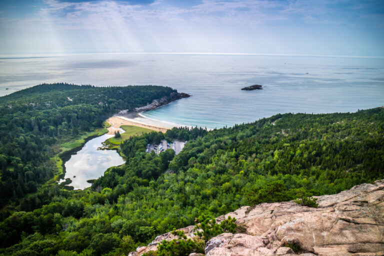
Bend, Oregon
Related Posts
What Is the Best Time to Go to Hiking in Bend, Oregon?
Before going through all the top hikes near Bend, knowing when to visit is a must. As a general rule of thumb, the best time to visit is between June and September, at the height of the summer season.
Here’s a quick dive into the pros and cons of each season in Bend.
Springs | March to May
With daily highs of around 59°F and lows hitting 30°F, spring is still a fairly cool time to visit. Many of the alpine lakes around the town are still thawing out from winter, and some of the colorful wildflowers begin to bloom.
As such, it’s still a relatively quiet time of the year on the hiking trails, but the ski slopes are still super busy.
Summer | June to August
As things heat up, the summer crowds begin to fill up the hotels and hiking trails. Temperatures usually reach 84°F and can get as low as 46°F on cooler days. These balmy temperatures, paired with minimal rainfall, make Bend perfect for paddleboarding, hiking, and much more.
Autumn/Fall | September to November
Fall is when you’ll see the most change in climate of the entire year. September sees maximums of around 73°F, but things cool fairly quickly, as November experiences highs of 48°F. As such, September is still a fantastic time to visit for hiking and just about any other outdoor activity.
However, accommodation and activities are a bit cheaper from October onward, so that’s worth keeping in mind.
Winter | December to February
While it’s not the best time for hiking, winter is the other tourist peak season in Bend. This is largely thanks to the magical ski slopes found at Mount Bachelor. Temperatures are generally below freezing, but you can expect average daily highs of around 41°F.

Top Tip: If you do intend to visit Bend during these months, check if you have all the necessary winter hiking gear.
Tours Of Bend, Oregon
How to Get to the Best Bend, Oregon Hikes
Thanks to Bend’s perfect location in central Oregon, getting to this quintessentially American town isn’t too difficult
If you’re looking to fly in, the nearest major airport is Redmond Airport (RDM). It’s a short 20-minute drive to Bend, and you can easily rent a car from the airport. If you’re looking to take a road trip through Oregon, there are a couple of ways to get to Bend.
It’s roughly a three-hour drive (163 miles) from Portland, mainly along the US-26 East and US-97 South. Traveling from Eugene is approximately a two-and-a-half-hour drive (129 miles) along OR-126 East and US-20 East.
Other major cities like San Francisco in California or Seattle in Washington will take you anywhere from seven to ten hours to drive. So flying and renting a car from Redmond Airport may be easier.
Where to Stay When Hiking in Bend, Oregon
Now that you know when and how to visit for a Bend hiking getaway, it’s time to pick a place to rest. Knowing where to stay in Bend isn’t easy, especially considering the amazing yet pretty pricey options available.
Budget | Campfire Hotel
The Campfire Hotel is a hidden gem amongst the more opulent lodgings that pepper this magical town. Each room has a unique blend of natural tones to create a comfortable and homely feel, all while embracing the modern luxuries you come to expect from a top hotel.
When you’re not resting in your room, you can enjoy some truly delectable American classics at the on-site restaurant, Canteen Bar. If that’s not enough, there’s also an on-site store for all your hiking essentials.
While that’s great for your daily adventures, the crystal-clear pool and spa are perfect for unwinding after a day of exploring. >>>Check Availability
Mid-Range | Riverhouse on the Deschutes
For a family-oriented hotel with loads of accommodation options, the Riverhouse on the Deschutes is simply sublime. From rooms with patios overlooking the Deschutes River to tucked-away cabins surrounded by wildlife, you’re not short of options.
They also offer a stunning range of food where French and American cuisine intertwine in one delightful dance of flavors. It’s also a pet-friendly accommodation, so the dogs can join the trip.
Resting in the northern suburbs of Bend, it’s also really easy to get to most of the top parks around the city. >>>Check Availability
Luxury | Tetherow Hotel
If you prefer something a little bit more upscale, then the Tetherow Hotel is a fantastic choice. Resting on the outskirts of West Bend, you can enjoy the quiet tranquility of the Deschutes River away from the busy downtown region.
You’ll also be a short drive away from Deschutes National Forest, where most of the top hikes, like the Tumalo Mountain Trail, can be found. When you’re not exploring the outdoors, there are three on-site restaurants to pick from and some lovely patios offering glorious sunset views. >>>Check Availability
Camping | Thousand Trails Bend-Sunriver
If you’re looking for something a little bit more rustic, consider camping at the Thousand Trails Bend-Sunriver. From RV sites and traditional camping spots to simple cabins, there are a lot of options out here.
It’s also much more than a campsite, though, as it has loads of amenities for you to enjoy. They offer everything from hiking trails and fishing spots to recreational activities like pickleball and mini golf.
To make things even better, it’s also a pet-friendly camping option, and it’s open year-round. >>>Check Availability
Read More: Where to Stay in Bend, Oregon | 7 Top Hotels & Hidden Lodgings
21 Best Hikes Near Bend, Oregon
Now that all the finer details are sorted, it’s time to dig into all the best hikes Bend, Oregon, has to offer. From gentle strolls perfect for soft hiking to treks for the most experienced hiker, this list has it all.
1. Tumalo Falls Trail
- Distance: 0.6 miles (out-and-back)
- Elevation Gain: 150 feet
- Difficulty: Moderate
- Trail Guide: Link
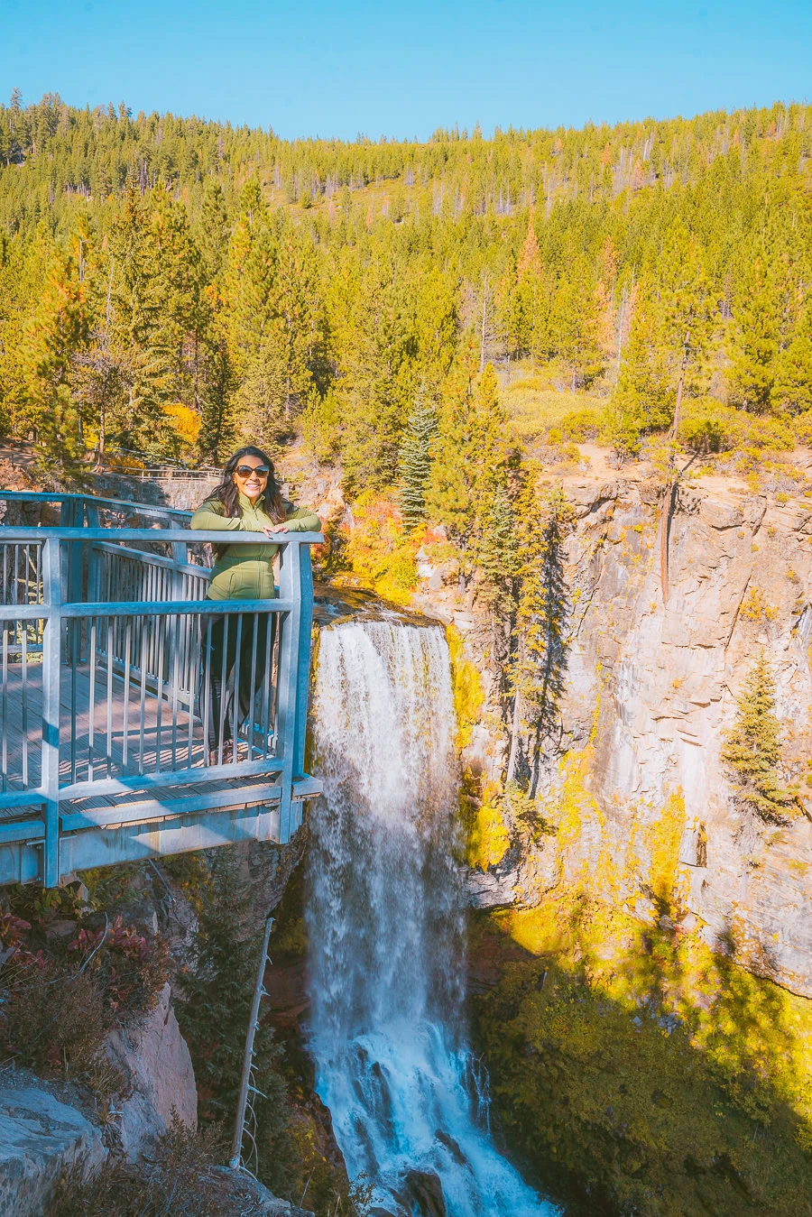
Don’t let its short distance deceive you. The Tumalo Falls Trail is still a fairly challenging hike due to the elevation gain.
Starting at the parking lot on Tumalo Falls Road, there’s a photo opportunity near the information center. However, you’ll definitely want to carry on to see the best views of the falls. It is a reasonably steep, thigh-burning trek along the North Fork Trail up to the viewing deck.
Once you reach the top, you can see the blanket of water cascading down the cliffside, with Ponderosa pine all around. It’s a truly magical site, but try to get there early in the morning, as it’s an extremely popular hike.
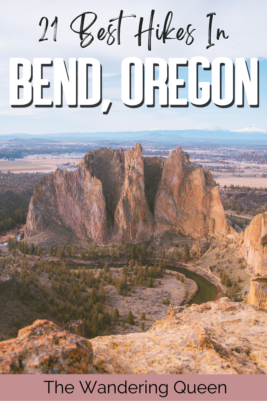
2. Misery Ridge Trail
- Distance: 2.6 miles (out-and-back)
- Elevation Gain: 1,138 feet
- Difficulty: Hard
- Trail Guide: Link

Hiking in Smith Rock National Park is an unforgettable experience, and possibly the cream of the crop is at Misery Ridge. It’s a strenuous trek that winds past Crooked River up to the lookout point, where some truly unbelievable rock formations await.
It’s a hefty 1.2-mile uphill climb to the viewing point for Monkey Face. It’s an unmistakable column overlooking Crooked River and Misery Ridge. All-in-all, this is a stunning hike as you pass under staggering ridges, around jagged cliffs, and along a forever-flowing river.
Top Tip: It’s a two-hour trek in total, and the trail gets really busy in summer. Aim to visit around dusk and enjoy the myriad of colors as the sunset paints the ridge in golden hues.
3. Proxy Falls Trail
- Distance: 1.6 miles (loop)
- Elevation Gain: 164 feet
- Difficulty: Moderate
- Trail Guide: Link

For a gentle stroll through the Willamette National Forest, consider taking on this 40-minute hike. Formed nearly 6,000 years ago, glaciers and lava flows have formed this gentle stream now known as Proxy Creek.
This isn’t the only body of water you’ll encounter as you pass through the deciduous forest, as you need to cross White Branch Creek to reach the falls. You’ll be able to first visit the Lower Proxy Falls before heading to the Upper Falls.
Each section offers a refreshing spray of water as the falls seemingly disappear as it hits the ground. This is due to the porous lava, though, which makes a lot of the water sink underground.
PS: The path is lit up by stunning fall foliage come autumn, and if you want more of a downhill trek, consider doing the hike clockwise instead.
4. Sahalie & Koosah Falls Trail
- Distance: 2.4 miles (loop)
- Elevation Gain: 364 feet
- Difficulty: Moderate
- Trail Guide: Link

If you want a quintessential Bend hiking trail, this moss-laden path is sure to tick all the boxes. Throughout the hour trek, you’ll pass seven glorious viewpoints, each offering a distinctive dive into Oregon’s natural beauty.
Starting at the Sahalie Falls Parking, views of Sahalie Falls greet you straight away. It’s then a 0.4-mile stroll downhill to the first viewpoint of Koosah Falls. You then continue downhill to Carmen Reservoir, where you may see people kayaking along the picturesque body of water.
The hike then wraps around to the McKenzie River Trail, where two more viewpoints of each fall await. Towards the last stretch of the trail, you’ll go on a bridge over McKenzie River, offering the perfect photo opportunity.
Note: You’ll need a day pass to enter Willamette National Forest.
5. Salt Creek Falls Trail
- Distance: 0.6 miles (out-and-back)
- Elevation Gain: 223 feet
- Difficulty: Moderate
- Trail Guide: Link
For another short but breathtaking hike in Willamette, this trek offers mesmerizing views of Salt Creek Falls. The trail leads you through a Douglas Fir forest, which creates a tapestry of color in late fall as the leaves change color.
The first half of the hike is all downhill, so it’s pretty easy getting to the viewpoint. Once there, it’s your chance to admire the Salt Creek Falls as they cascade 286 feet into the icy pool below. The real challenge comes on the way back to the trailhead, as it’s all uphill from there.
Download my free Outdoor Photography Guide
6. Cleetwood Cove Trail
- Distance: 2.1 miles
- Elevation Gain: 610 feet
- Difficulty: Moderate
- Trail Guide: Link

Head just south of Bend, and you’ll find the wonderful world of Crater Lake National Park and this lovely one-hour and 15-minute hike. It’s a zigzagging trail that leads you all the way from East Rim Drive down to the shores of Crater Lake.

From the shores, you’ll have clear views of Mazama Rock to your left, Garfield and Applegate Peak straight ahead, and Hillman Peak to your right. Getting to the shores is all downhill, which is fairly easy, but the trek back to the parking lot is relatively strenuous.
This is the ideal place to relax, have a swim, and just enjoy the scenery of Crater Lake.
Note: You will need to pay an entrance fee to access the hike. Rim Drive is also closed during winter, so avoid visiting during this time.
7. Toketee Falls Trail
- Distance: 0.8 miles (out-and-back)
- Elevation Gain: 170 feet
- Difficulty: Moderate
- Trail Guide: Link

Admiring a tranquil waterfall creating a white blanket over striking columnar basalt cliffs isn’t a dream but rather something very real at Toketee Falls. It’ll take you just 15 minutes to reach the falls from the parking lot, but there’s plenty to enjoy along the way.
Roughly 500 feet into this gentle trek, you’ll encounter the first viewpoint, overlooking the river and distinct cliff-face in the distance. The real difficulty in this trek comes toward the end, as there’s a steep decline as you head to the base of the falls.
Top Tip: It’s best to wear good-quality hiking boots so you don’t slip when descending or ascending the last section of the hike.
8. Steelhead Falls Trail
- Distance: 2 miles (out-and-back)
- Elevation Gain: 200 feet
- Difficulty: Moderate
- Trail Guide: Link

The Deschutes Canyon is teeming with natural beauty, and if you want to experience it all, this 50-minute trek is the ideal way to do so. The trail follows alongside the Deschutes River and reveals some secret gems.
It’s all downhill to start as you follow the river downstream. Around half a mile in, you’ll see the remnants of an old mill, showcasing the river’s significance for past generations. Just a bit further on from there, you’ll find a small eddy offering the perfect swimming spot.

Beyond the eddy, roughly 0.6 miles into the hike, you’ll be blessed by fantastic views of the Steelhead Falls. The rest of the trail leads you on from the falls towards tranquil waters, offering more swimming spots few can pass up.
9. Deschutes River Trail
- Distance: 4.4 miles (loop)
- Elevation Gain: 157 feet
- Difficulty: Easy
- Trail Guide: Link
While the Deschutes River Trail can stretch for as long as 12 miles, the best section you absolutely have to take on is at Old Mill Reach. This gentle hiking trail in Bend, Oregon, takes around an hour and a half to complete, but you’ll pass some stunning parts of town.
From boardwalks and bridges to well-worn paths, you and your pets can take in the views of Bend’s riverside districts. Some notable landmarks you’ll pass include the Les Schwab Amphitheater and Farewell Bend Park, just to name a few.
PS: This is also a great trail to take for biking.
10. Green Lakes Trail
- Distance: 9 miles (out-and-back)
- Elevation Gain: 1,174 feet
- Difficulty: Moderate
- Trail Guide: Link
Kicking off at the Green Lakes Trailhead, this is an amazing day hike that’ll take you just under four hours to complete. Just north of Sparks Lake, you’ll travel alongside Fall Creek, one of the lake’s tributaries.
Throughout the hike, you can stop at each of the small waterfalls, either for a refreshing splash to the face or for a memorable photo. Roughly two miles in, the trail forks to the right, leading you straight to the Green Lakes.
You’ll notice loads of campsites available around each green lake, so it’s also a great trail for a night among the stars.
Note: The Three Sisters Wilderness Areas require permits and parking fees for some trailheads.
11. South Sister Trail
- Distance: 11.6 miles (out-and-back)
- Elevation Gain: 4,986 feet
- Difficulty: Hard
- Trail Guide: Link
As the third tallest peak in Oregon, reaching the summit of South Sister is fairly challenging. This day-long trek starts off gently as you travel between Kaleetan Butte and Devil’s Hill all the way to Moraine Lake Trail.
From the lake — which is a great place to stop — you’ll encounter a sandy plain, a relatively flat mile-long section. This gentle gradient quickly disappears, though, as you reach the base of South Sister.
From here, it’s a 2.4-mile slug up the mountain. As you make you’re way up, rest at the lovely lake at the base of Lewis Glacier. As you walk near Lewis Glacier and up to Cinder Ridge, marking the final mile point. At the summit, you’ll find an icy lake and magnificent views of the surrounding wilderness.
Note: You’ll need to register at the trailhead. If you don’t, you can face a $200 fine.
12. West Metolius River Trail
- Distance: 7.2 miles (out-and-back)
- Elevation Gain: 255 feet
- Difficulty: Easy
- Trail Guide: Link
For something slightly easier and ideal for a day-long meander, this two-and-a-half-hour Metolius River trek is simply sublime. You don’t have to complete the entire trail, but each bend of the emerald-colored river makes you want to take another step.
It’s a fantastic region to spot some endemic birds, like the song sparrow or red-breasted nuthatch. Around 2.3 miles into the hike, you’ll pass the Wizard Falls Fish Hatchery, which is sprawling with Canadian geese between May and June.
Aside from this, West Metolius River Trail is just a lovely walk if you’re looking for fresh air and something relatively easy.
13. Big Obsidian Flow Trail
- Distance: 0.62 miles (loop)
- Elevation Gain: 196 feet
- Difficulty: Moderate
- Trail Guide: Link
It may seem odd that a 10-minute walk is amongst a bunch of hikes, but this trail more than earns its place. Just 15 minutes from Downtown Bend in the Newberry National Volcanic Monument, you’ll find this obsidian lava flow.
About 1,300 years ago, an eruption caused this great lava flow, creating this iconic dark dome-like landmark. Throughout the short trek, there are two viewpoints of the lava flow and Paulina Peak.
Top Tip: Be sure to read the interpretive signs along the path for more details on this landmark’s impact on past generations.
14. Ray Atkeson Memorial Trail
- Distance: 2.4 miles (loop)
- Elevation Gain: 108 feet
- Difficulty: Easy
- Trail Guide: Link
Take on this 50-minute trail for an opportunity to explore the stunning shoreline of Sparks Lake. Just be sure to wear plenty of sunblock, as there’s little to no shade along the trail.
Despite the lack of shade, the hike takes you past lodgepole pines and between some stunning lava formations. With hardly any elevation gain, it’s the ideal soft hiking trail, and it’s also wheelchair accessible.
15. Pilot Butte Trail
- Distance: 1.8 miles (out-and-back)
- Elevation Gain: 456 feet
- Difficulty: Moderate
- Trail Guide: Link
If you’re looking for a great hike, Bend, Oregon, is synonymous with its Pilot Butte. Starting at the parking lot at Pilot Butte State Park, this is a spiraling trail that’ll take you roughly an hour to complete.
Bear in mind it’s all uphill hiking, but once you reach the top, you’ll realize it’s worth the burning thighs. At the summit, you’ll have lovely views of the suburbs below and the Cascade Mountains in the distance.
There’s a marker sighting compass at the summit, outlining the top landmarks in each direction. If you visit at sunset, you can get comfy on one of the many benches perched atop the butte.

16. Paulina Peak Trail
- Distance: 6.2 miles (out-and-back)
- Elevation Gain: 1,610 feet
- Difficulty: Hard
- Trail Guide: Link
Now, this is a pretty challenging hike, largely due to its intense elevation gain and lengthy three-and-a-half-hour trek time. While you can drive to the summit, where’s the fun in that?
Rather, tackle this trail, which starts at Paulina Lake and winds all the up the mountain. It’s the highest point in the Newberry region, so it offers unforgettable views of the landscape, which has been shaped by years of volcanic activity.
Top Tip: Keep an eye out for Central Pumice Cone towering above Paulina and East Lake.
17. Broken Top Trail
- Distance: 22.9 miles (loop)
- Elevation Gain: 3,914 feet
- Difficulty: Hard
- Trail Guide: Link
As the longest and most difficult trail on the list, you can imagine this nearly 11-hour trek has some stunning views. Before getting stuck into the top sights of the hike, it’s worth noting that doing the loop clockwise is ideal. It means you’ll get the greatest elevation gain out of the way early on.
Okay, now to dig into the sights of this epic hike. The first thing you’ll see is Three Creek Lake as you wind your way to the viewpoint of Broken Top. Below the peak rests Bend Glacier and Crook Glacier.
The trail then wraps around Broken Top and past the Green Lakes before looping all the back to the trailhead.
Top Tip: Consider camping at Golden Lake, roughly 15 miles into the hike going clockwise.
18. Crater Ditch Trail
- Distance: 7.8 miles (out-and-back)
- Elevation Gain: 1,446 feet
- Difficulty: Hard
- Trail Guide: Link
For a slightly different approach to Broken Top, consider taking on this challenging climb following the Crater Ditch Creek. It’s a constant uphill trek towards the viewpoint of Broken Top and the two glaciers just below the peak.
That said, you’ll also pass a few landmarks you would’ve otherwise missed just going the Broken Top Trail. One such landmark is Ball Butte, which towers over the trail. You’ll also get stunning views of No Name Lake, which is fed by the two glaciers and runs off into Crater Ditch Creek.
All the best views in the state
100+ WA Hikes
Embark on Washington’s best trails with our eBook! Inside, find top hikes, expert tips, and stunning views, making every adventure unforgettable. Dive into the beauty of Washington’s outdoors now!
19. Wolf Tree Trail
- Distance: 2.6 miles (out-and-back)
- Elevation Gain: 406 feet
- Difficulty: Easy
- Trail Guide: Link

Taking around an hour and 15 minutes to complete, this easy walking trail in Bend, Oregon, takes you to one of the oldest trees in Smith Rock State Park. Starting at the Oregon Movie Trail, you’ll cross a bridge over the Crooked River.
The trail then meanders alongside the river all the way to a small peak near Burma Road. At the summit, you’ll be able to see one of the oldest trees in the park, more commonly known as a Wolf Tree.
20. The Chute
- Distance: 0.5 miles (out-and-back)
- Elevation Gain: 167 feet
- Difficulty: Moderate
- Trail Guide: Link

As one of the most popular hikes in Smith Rock State Park, this 20-minute trail couldn’t be left out. Don’t let its length deceive you. It’s a real lung-buster, especially if you’ve already been hiking the entire day.
It’s a steep climb up to the top, but once you reach the summit, you’ll be met by some of the best views of Smith Rock.
21. Crooked River Trail
- Distance: 4.4 miles (out-and-back)
- Elevation Gain: 321 feet
- Difficulty: Easy
- Trail Guide: Link
Last but certainly not least, consider taking on the Crooked River Trail, an easy hour-and-a-half hike. It wraps around the iconic Smith Rock, much like the Crooked River does.
While the trail offers some fantastic riverside views, it’s a simply lovely hike if you’re looking to see wildlife like chipmunks and hummingbirds. Towards the end of the trail, you may even see Asterisk Pass, one of the narrowest points of Smith Rock between Crooked River.
FAQs About Hikes Near Bend, Oregon
As you can see, the hikes around Bend, Oregon, are simply out of this world. Magical hikes are one thing, but answering those nagging questions that pick at the back of your mind is another.
How Much Time Is Needed to Go Hiking Near Bend, Oregon?
If you want to enjoy the Bend to its brilliant best, consider staying for around four days. This gives you enough time to spend a day at each nearby park and one day exploring the best things to do in Bend itself.
What to Wear to Bend, Oregon?
As a general rule of thumb, it’s always a good idea to pack some warm clothes when hiking in Bend, no matter the season. Although it gets hot in summer and early fall, the nights still get chilly.
So bring light clothes for summer, thick thermals for winter, and a warm sweater all year round.
Top Tip: Consider using this fall hiking gear checklist to help you plan your general essentials for hiking around Bend, Oregon.
Why Is Bend, Oregon, so Expensive?
Unfortunately, it’s 31% more expensive to live or visit Bend than the national average. While you can avoid the high prices in spring and fall, it’s still fairly expensive. So bear this in mind when planning your trip, as it’ll probably cost a bit more than you initially thought.
Are Bend, Oregon, Hiking Trails Pet-Friendly?
Not all, but many of them are. Some trails, like the Upper Deschutes River Trail, allow dogs off-leash between 15 September and 15 April. However, in general, popular trails in the peak summer season, like the Green Lakes Trail, require the dogs to stay on the leash.
PS: Here’s a list of the best dog-friendly trails in Bend.
Are There Bears Along Bend, Oregon, Hiking Trails?
Yes, there are plenty of bears, coyotes, cougars, and some wolves that call the wilderness surrounding the town home. They are especially active in summer, which also happens to be the region’s peak tourist season. It’s a good idea to check out these wildlife safety tips before visiting.
Download my Washington Hiking Checklist!
What To Pack For Hiking In Bend

- Sunscreen: It might be extremely sunny! >Buy Sunscreen
- Chapstick: This one has SPF so your lips won’t get burned! >Check Out This Chapstick
- Hiking Boots/Shoes: If you want to hike any of the trails (especially Spirit Falls) then you need some good quality hiking shoes. >Check Out My Hiking Shoes
- Hiking socks: Having the correct socks helps you prevent getting blisters. Smart Wool is probably my favorite brand out there. >Buy Hiking Socks
- Water Reservoir: Water reservoirs help prevent me from getting dehydrated while hiking. The great thing about this reservoir is that it doesn’t have a plastic taste. >Here Is My Water Reservoir
- Water: Stay nice and hydrated.
- Sunglasses: It can get sunny all year round, so make sure to pack some sunglasses. >Check Out These Sunglasses
- Snacks: The best snacks are jerky, nuts, and energy bars. >>>I Love These Bars
- Camera: The Sony A6000 was one of the first cameras I started traveling with. The Sony A6000 is an excellent camera for people that want to start improving at travel photography. >Buy Sony Camera Here
- First Aid Kit: This is one of the first things I bought when I first started going on adventures. It is super portable. >Buy This Awesome First Aid Kit Here
- Day Pack: To carry all your gear, water, and food, you need a good backpack. Osprey is known to have some of the best backpacks in the market. >Buy This Great Quality Backpack
- Headlamp: A headlamp is an absolute must in case you get stranded in the dark! It is a lot more portable and easier to use than a flashlight. >Buy A Headlamp Now
- Leggings or Hiking Pants: I always wear leggings while hiking because it is what I feel most comfortable with! >Click For My Favorite Hiking Leggings
- Breathable sweat-wicking shirts: Cotton shirts soak up your sweat when hiking, so make sure to wear something breathable. >Check out this awesome breathable shirt here.
- Mid Base Layer: If you are hiking in the winter, this might be a great idea. >Check Out My Sweater Here
- Sports Bra: For women. >Check This One Here
- Jacket: I always have a jacket in my backpack, even if it is hot. I do it just in case of an emergency. >Buy My Favorite Jacket
- Rain Jacket: The worst feeling in the world is being wet and cold while hiking. You can get hypothermia, so always carry a poncho or a rain jacket when you hike in Oregon. If you look closely at my pictures, it is raining in most pictures. >Check Out My Rain Jacket Here
- Tripod: This is an optional item, but it is excellent for getting the ideal silky waterfall pictures. >Check out this tripod
- Knife: I always carry a knife in my backpack just in case. >Check Out My Knife Here

Claim your FREE Hiking Checklist
Ready to start hiking? Grab my free hiking checklist and never forget anything at home!
Final Thoughts on the Best Bend Hikes
As you can see, some of the best hikes in central Oregon are actually in and around Bend. While you do have to do a bit of a drive to get to some of them, the magical views and unforgettable moments all make up for it.
If you’re looking for some more Oregon inspiration, have a look at the top hikes in Crater Lake National Park.
It’s safe to say whether wandering through Bend or visiting the coastal oasis of Astoria, Oregon is a destination like no other.